Worth its Salt: Tramway Trail and Craig Canyon, Saline Valley

Dawn comes to Saline Valley and the mighty Inyos.

Dawn comes to Saline Valley and the mighty Inyos.

We recently took our new truck for a break-in jaunt into Saline Valley, the huge valley just east of Owens Valley. The west side of Saline is formed by the rugged Inyo Mountains, and the valley contains dunes, hot springs, pure stands of pickleweed, and — at this time of year — wildflowers. We filled up the weekend with a hike up the steep and historic Salt Tramway Trail, and got a different look at the Inyos from the inside with a short jaunt up Craig Canyon.

Salt Tramway Trail

Michel Digonnet, author of the indispensable-for-desert-travelers Hiking Western Death Valley National Park, gives special attention to the Salt Tramway of Saline Valley. The biggest mining venture in Saline Valley involved not precious metals, but humble halite (table salt). “Discovered” in the late 1800s, Saline Valley Salt Lake underwent serious exploitation around 1911. Construction of a 13.5-mile aerial tramway began soon after. From the valley floor at 1100′, it would climb almost 8,000′ to cross deep Daisy Canyon, continue upward to the almost 9,000′ crest of the Inyos, then drop more than 5,000′ down the other side to a railroad terminus on the shore of Owens Lake.

The tramway was powered by electric motors and called for 2 terminals, 4 intermediate control towers to change direction of the cables, 21 rail structures, and 12 anchorage-tension stations.When completed in 1913, it became the steepest tramway in the US — and remains one of the largest of its kind today (from Digonnet).
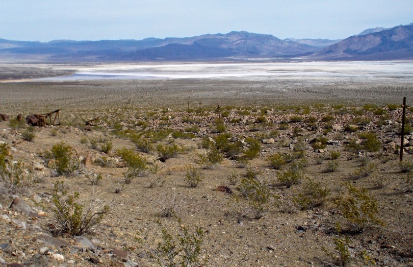
Saline Valley Salt Lake at 1100', where halite was mined and then transported up and over the 8700' crest of the Inyo Mountains to Owens Valley. A 13.5 mile long aerial tramway was built in 1913 to do the hauling.

Saline Valley Salt Lake at 1100′, where halite was mined and then transported up and over the 8700′ crest of the Inyo Mountains to Owens Valley. A 13.5 mile long aerial tramway was built in 1913 to do the hauling.

Up, up, and up some more: at a thousand feet per mile, the trail passes 10 tramway stations along the edge of Daisy Canyon before crossing it, then passes by stations 11-20.

Up, up, and up some more: at a thousand feet per mile, the trail passes 10 tramway stations along the edge of Daisy Canyon before crossing it, then passes by stations 11-20.

Looking down at Station 4 of 20. This project used 1.3 million board feet of lumber, 54 miles of cable, and 650 tons of nuts and bolts. And no helicopters.

Looking down at Station 4 of 20. This project used 1.3 million board feet of lumber, 54 miles of cable, and 650 tons of nuts and bolts. And no helicopters.

Control Station 5, where the cables changed direction.

Control Station 5, where the cables changed direction.

During the 12 years this tramway operated, 30,000 tons of salt were shipped over the mountains to Owens Valley. *Mike for scale.

During the 12 years this tramway operated, 30,000 tons of salt were shipped over the mountains to Owens Valley.

Spot the horned lizard and win a prize!

Spot the horned lizard and win a prize!

The next station above the #5 control station. Anyone in for an historic, exciting zip-line adventure on vintage, unmaintained mining detritus far from any professional medical assistance? Fred and Laura, maybe some bone-broth stations at the top or bottom?

The next station above the #5 control station. Anyone in for an historic, exciting zip-line adventure on vintage, unmaintained mining detritus far from any professional medical assistance?

The longest shovel ever.

The longest shovel ever.

Eventually tne trail becomes a bit of a catwalk threading its way between cliff bands along a steep side canyon. — with Mike Hay.

Eventually the trail narrows and threads its way between cliff bands along the side of the canyon.

The trail is still intact as it approaches Station 9. We have ascended about 4000' in 5 miles, yet are still 5 miles from the Inyo crest. — with Mike Hay.

The trail is still intact as it approaches Station 9. We have ascended about 4000′ in 5 miles, yet are still 5 miles from the Inyo crest.

View from Station 10, at the edge of Daisy Canyon, where the trail disappears. To get to Stations 11-20 (11 is on the skyline), one would need to drop 1000' down to the canyon bottom and back up the other side. We turned around here.

View from Station 10, at the edge of Daisy Canyon, where the trail disappears. To get to Stations 11-20 (11 is on the skyline) and remain on the trail, one would need to drop 1000′ down to the canyon bottom and back up the other side. We turned around here.

Enjoying the softening light on the late-afternoon descent ... thinking about the fact that we're just about out of water and that there is beer down at the truck ...

Enjoying the softening light on the late-afternoon descent … thinking about the fact that we’re just about out of water and that there is beer down at the truck …

... as shadows begin to creep across the valley floor.

… as shadows begin to creep across the valley floor.

Steep, deep and fall-ridden: Craig Canyon

Collared lizard enjoying the morning sun.

Collared lizard enjoying the morning sun.

Craig Canyon is just north of Daisy Canyon and the Salt Tramway, so we explored it a little the next day right from camp. In just 2 miles we scrambled up numerous small falls and bypassed 2 large ones. As Digonnet says, “The lower canyon offers a relatively easy hike to exceptional narrows that rank among the deepest and tightest in this range. For a change there is no running water or bramble to make hiking a nuisance.” 

The Big Silver Mine at the entrance to Craig Canyon.

The Big Silver Mine at the entrance to Craig Canyon. “Rustic! Landscaping! Not too much hantavirus! Free spiders!”

Amazing layered rock in lower Craig Canyon. This is one of a handful in the Inyos that are not choked with water (and impassable brush).

Twisted, layered rock in lower Craig Canyon. This is one of a handful of canyons in the Inyos that are not choked with water (and thick brush).

Mike checks out the granite quality. The rock in the canyon included limestone, shale, granite, conglomerate, and probably many more!

Mike checks out the granite quality. The rock in the canyon included limestone, shale, granite, conglomerate, and more.
We passed several falls, which were short and climbable with options of varying difficulty.

We passed several falls, which were short and climbable with options of varying difficulty.

Nothing ever stands still in these canyons. This had been washed down and deposited in the streambed. Subsequent alluvial deposition covered it. Now those depositional layers are being eroded out, which has exposed the log.

Nothing ever stands still in these canyons. This log had been washed down and deposited in the streambed. Subsequent alluvial deposition covered it. Now those depositional layers are being eroded out, which has exposed the log.

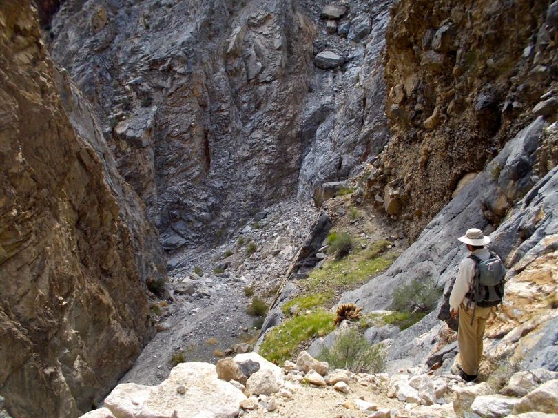
View from the top of the first large (50') fall, which we bypassed on ledges.

View from the top of the first large (50′) fall, which we bypassed on ledges.

Top of second large fall, also bypassed on ledges near the giant cactus at right.

Top of second large fall, also bypassed on ledges near the giant cactus at right.

Two miles up-canyon, we enter a spectacular narrows of polished limestone.

Two miles up-canyon, we enter a spectacular narrows of polished limestone.

This must have been exciting when it flooded.

This must have been exciting when it flooded.

Violent and rapid water flow had undercut these limestone walls.

Violent and rapid water flow had undercut these limestone walls.

Rock-studded dried mud made up some of the walls in the narrows.

Rock-studded dried mud made up some of the walls in the narrows.

After the narrows, we came to a third fall, maybe 30' high. This may be passable with some gear for protection, but we turned around here.

After the narrows, we came to a third fall, maybe 30′ high. This may be passable with some gear for protection, but we turned around here.